 |
WHEN YOU ARRIVE.
- Park your car in our parking lot. Unload your gear at the host hut, but your car must be parked just as soon as you unload. This is a load and unload zone only.
- Register at the host hut or with the camp host. Camp hosts signs will be found in the parking lot area. You need to register before you set up your tent, go to the beach, visit with your friends, walk the dog, etc.
- After you register you’re free to enjoy TRC!
NOTE ABOUT THE FIRE SUPPRESSION SYSTEM: The water provided by the shared fire suppression system is not for consumption and shall not to be used for drinking, washing, or any other purpose other than emergency fire suppression situations. |
TRC Trail Guide
Hiking trails accessed from TRC property (See map):
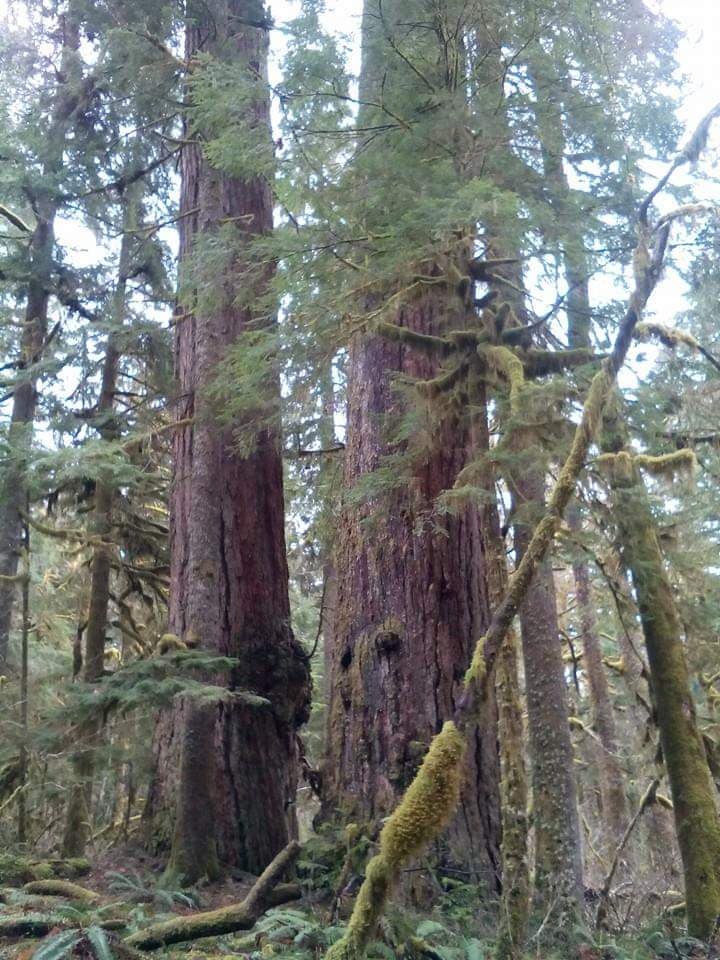
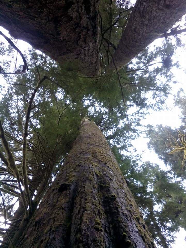
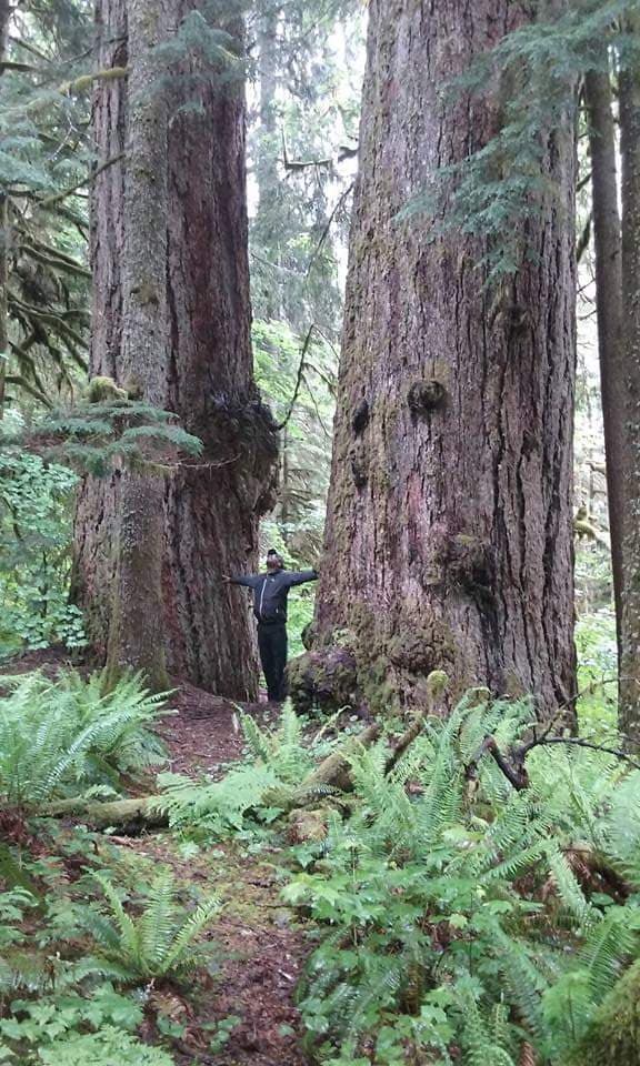
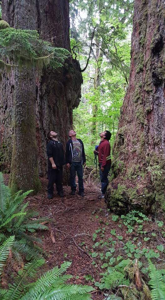
1. Giant Trees – (approx ½ mile RT) Short very easy trail to some amazing old growth Douglas firs and “the twins”. These massive trees are said to be the oldest and biggest in the Robe valley (400-600 years old!) Legend has it that they were saved by the original loggers because they were used as anchor trees to which chains were attached to pull logs down to the railroad tracks where Mountain Loop highway is today.
To find: On the way up the dirt road you will pass the large water storage tanks on your right. Continue up the road and you will see the old homestead cabin on your left (do not enter). On the right side of the road across from the cabin you will see a small grass parking strip. The trailhead is located just uphill from that on the right side, marked with a sign.
2. East Falls – (approx 2 miles RT) Steep trail up to small waterfalls and great views. Falls are flowing best before all the snow has melted. The trail consists of walking on rock and boulders and gets steeper as you go, nice workout. This natural rock slide provided the stone for a former quarry in operation at the site.
To find: Walk or drive up the dirt road to the end which is the quarry parking lot. Facing the mountain, walk straight ahead over the berm, then continue straight ahead up the gulch in front of you.
3. Upper Loop Trail to Marble Peak viewpoint – (approx ½ mile RT) Easy mostly level trail through lush forest to a spot with an open view of Marble Peak across the valley. (From here the old trail continued up to West falls but has been overgrown and lost. Dotted line on map. Currently working on restoring the trail to West falls.)
To find: Walk or drive up the dirt road to the end which is the quarry parking lot. Facing the mountain, walk straight ahead over the berm and then look for the trailhead on your left. The entrance is marked with branches and blue trail marking tape on a tree. The trail heads west from the quarry.
4. Lower Loop Trail – (approx ¼ mile RT) Very easy mostly level trail through pretty forest on the bluff above the stream bed. On the ground is a carpet of moss, vibrant green in the rain. (This trail used to connect to Upper Loop trail but has not been maintained beyond the first section. Currently working on trail restoration.)
To find: Walk up the dirt road past the small white water tank on the left. A little further up you will see a small parking spot on your left and a trail going up the bluff from the road. Walk up the bluff to find the level trail above.
Other hiking trails nearby which require a short drive:
5. Kelcema Lake – (trail 1.2 miles RT) Short easy hike leads to a gorgeous alpine lake on the north side of Long mountain. Not crowded like most other alpine lakes in the area. Cobalt blue water, great spot for swimming. When facing the lake, the trail to your right leads to a huge rock which has a nice view over the lake.
To find: From TRC drive 2 miles east, just past the town of Silverton, to Deer Creek Road (NF-4052). Turn left and follow Deer Creek Road for 4 miles. It is an unpaved gravel/dirt road but most cars can make it. Great views along the way up. Trailhead is on your left. Northwest Forest Pass is required for parking at the trailhead although rarely enforced here.
https://www.wta.org/go-hiking/hikes/kelcema-lake
6. Big Four Ice Caves – (trail 2.2 miles RT) Easy walk on a boardwalk over bogs, then a bridge over the river (bridge might still be under repair so you may have to walk through the river to cross) and then an uphill dirt trail takes you to the spectacular ice caves. Big Four mountain is impressive and the ice caves are super cool. It is a popular destination and can get crowded on weekends.
To find: From TRC drive on Mountain Loop Hwy approx 6 miles east. There are two signs for the Ice Caves on the right hand side of the road. The first one will be for the picnic area which is currently closed. A quarter-mile beyond that is a sign marked Ice Caves Trailhead, turn in here. There is a paved parking lot, vault toilets, and a self-serve pay station for a Northwest Forest Pass which is required here.
https://www.wta.org/go-hiking/hikes/big-four-ice-caves
7. Monte Cristo Ghost Town – (trail 8 miles RT) Monte Cristo was a booming silver mining town with over 1000 residents at it’s peak in 1894. It was the end of the line of the Everett and Monte Cristo Railroad and the locomotive turntable is still there, along with several vacant buildings, a few old signs and rusty mining equipment laying in the fields. Most of the trail is on an old road which is easy to walk, but there are some sections through the forest and you have to walk over a log to cross the Sauk river. Spectacular mountain views.
To find: From TRC drive approx 11 miles east on Mountain Loop highway to Barlow pass. Northwest Forest Pass is required for parking at the trailhead.
https://www.wta.org/go-hiking/hikes/monte-cristo-143